1. Context and purpose
The purpose of hydrological models is to estimate spatially distributed hydrological discharge, by modeling the complex multi-scale and multi-physics processes that link it to rain and precipitation data. These processes are often not well-known, and most hydrological models are built with a top-down approach to process modeling. They attempt to model large scale (temporal and spatial) basin response through empirical or conceptual description of the phenomenons.
1D hydraulic models, that rely on physics-based bottom-up approach to model riverine flows, can be coupled to hydrological models to handle the propagation of distributed hydrological discharge through river networks and improve downstream performance, where inaccuracies carried by simpler routing methods can compound.
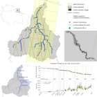
Figure 1: The Maroni basin. Left: In gray, extent of the hydrological model (distributed of a 1×1 km² grid). In yellow, extent of the hydraulic model, derived from the SWOT River Database. Right : zoom on hydraulic grid (yellow) vs hydrological grid cells outputs to couple (red).
The assimilation of river observations (e.g. in situ gauges, water surface elevation through satellite altimetry) into hydraulic models with variational methods has shown promising results in recent years (see e.g. [1,2,3]). Managing to bring the information carried by these observations upstream, i.e. up to the distributed hydrological discharge and the hydrological model, represents a very interesting venue to both improve the calibration of the hydraulic and hydrological parts of the coupled model.
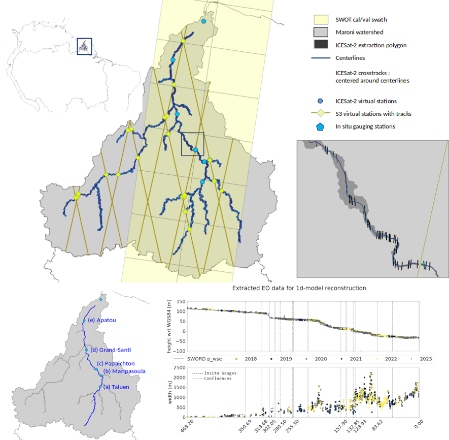
Figure 2: In situ and satellite observability of the Maroni basin. Observations carry information on river geometry, useful to build the model, and on basin response, seen heterogeneously throughout the hydraulic domain, useful for calibrating the model.
In the next part of this series, we will look into the coupling method put in place between the SMASH distributed hydrological model and the DassFlow1D hydraulic model. This coupling is an integral part of the direct simulations and of the variational calibration process.
[1] Garambois, P. A., Larnier, K., Monnier, J., Finaud-Guyot, P., Verley, J., Montazem, A. S., & Calmant, S. (2020). Variational estimation of effective channel and ungauged anabranching river discharge from multi-satellite water heights of different spatial sparsity. Journal of Hydrology, 581, 124409. https://doi.org/10.1016/j.jhydrol.2019.124409
[2] Pujol, L., Garambois, P. A., Finaud-Guyot, P., Monnier, J., Larnier, K., Mose, R., … & Calmant, S. (2020). Estimation of multiple inflows and effective channel by assimilation of multi-satellite hydraulic signatures: The ungauged anabranching Negro river. Journal of Hydrology, 591, 125331. https://doi.org/10.1016/j.jhydrol.2020.125331
[3] Larnier, K., Garambois, P.-A., Emery, C., Pujol, L., Monnier, J., Gal, L., et al. (2025). Estimating channel parameters and discharge at river network scale using hydrological-hydraulic models, SWOT and multi-satellite data. Water Resources Research, 61, e2024WR038455. https://doi.org/10.1029/2024WR038455