
1D hydraulic models are powerful tools to conduct fine-scale analysis of the main river flows. The setup of such models relies on the definition of the river geometry that describes both the river planform (in curvilinear 1D network) and the topography of the riverbed along the river network. Thus defining the model geometry is twofold: (i) the definition of the river network and the location of the cross-sections (computation nodes) along this network and (ii) the geometry of each cross-section (see Figure 1). Usually both these two aspects of the geometry are computed from field survey data for the riverbed topography and a DEM (Digital Elevation Model) for the floodplain. In this series of articles we present a new methodology to leverage multi-sources Earth Observation (EO) data to estimate the geometry. This methodology is crucial for areas where collecting field data is difficult due to several reasons (topography or vegetation, political or transboundary issues, etc.).
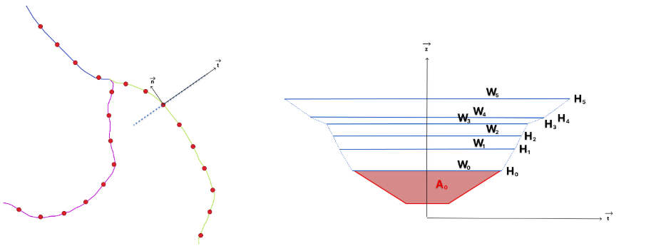
Figure 1: River geometry: (left) river network in solid lines and location of the cross-sections (red dots), (right) geometry in (t,z) plane for the considered cross-section in the left pane.
In the next part of this series, the application of this methodology will be presented on the Garonne River basin in France. Part 2 will introduce the EO data of interest and how to preprocess them and part 3 will present the core components of the method with its application to build a 1D hydraulic model the Garonne River basin.
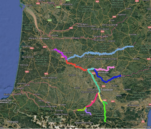
Figure 2 : Considered network of the Garonne River basin, south-west of France.


How to use satellite observations to build a 1D hydraulic model, part 2 : data and preprocessing - Hydravatar
[…] presented in part 1, the definition of the geometry of a 1D hydraulic model is twofold: a) the river network planform […]
How to use satellite observations to build a 1D hydraulic model, part 3 : methodology and application - Hydravatar
[…] for the hydraulic model, namely the bathymetry (or equivalently the unobserved flow area A0 in part 1 – Figure 1) and the friction coefficient are estimated using usual methods (inversion of the Manning equation, […]