
Differentiable, Regionalizable Hydrological–Hydraulic Framework for Learning from SWOT and Sparse Discharge Observations at Basin Scale
A major research breakthrough in hybrid hydrological-hydraulic modeling has been achieved by the laboratories involved in the project and demonstrated in a pilot case study within the Hydr’Avatar project. By combining artificial intelligence, physics-based modeling, and SWOT satellite altimetry, the team has developed a novel data assimilation framework with the potential to substantially improve river flow forecasting in ungauged catchments.
A Cutting-Edge Hybrid Paradigm
This new framework relies on the differentiable coupling of two core numerical engines:
- SMASH: A fully distributed rainfall-runoff hydrological model with learnable regionalization (Huynh et al. 2024) and flux corrections (Huynh et al. 2025, 2026).
- DassFlow-1D: A hydraulic river network model solving the 1D Saint-Venant shallow water equations for river flow and stage modeling.
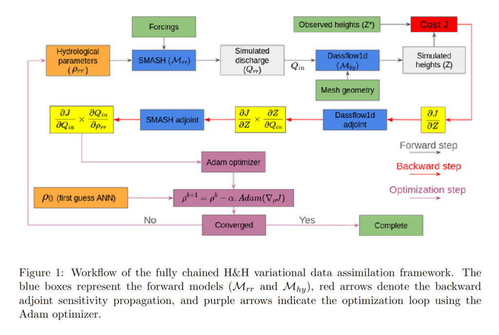
The hydrological-hydraulic (H&H) framework is built around key concepts of hydrological closure (Larnier et al. 2025) and bidirectional information feedback (Pujol et al. 2022, Pujol et al. 2026). SMASH provides mass-conservative inflows that constrain hydraulic inference, while hydraulic observations and sensitivities feed information back to hydrology. Neural networks regionalize parameters, and differentiable coupling enables joint learning of H&H parameters from SWOT and sparse in situ discharge observations while preserving physical consistency of simulated states and fluxes at basin scale.
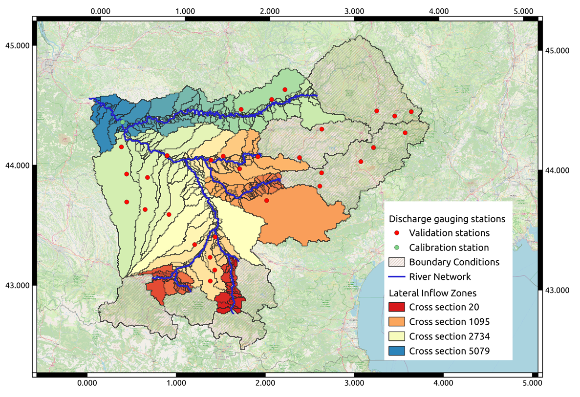
To bridge these models seamlessly, dedicated preprocessing aligns land-pixel lateral inflows from SMASH to exact injection points along the DassFlow-1D river network following (Berkaoui et al. 2026). Built within a PyTorch-based, gradient-aware environment using an adjoint-state formulation, the entire pipeline remains end-to-end differentiable via the chain rule. This allows river-level observation errors to backpropagate directly into the inverse calibration of regionalized hydrological parameters.
Proven Performance Across the Garonne River Basin
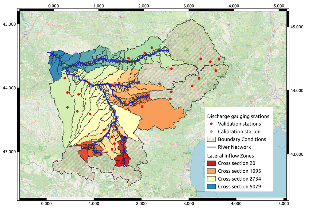
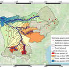
The setup was evaluated across the Garonne River basin, coupling SMASH at 1 km resolution and hourly time steps with DassFlow-1D at 200 m resolution and 5-minute time steps. The experiment represents a genuinely poorly gauged scenario: the hydraulic geometry was established a priori, using satellite imagery, Sentinel water masks processed through SERTIT’s ExtractEO Cube, and SWOT and multi-mission nadir altimetry to derive dry-bed geometry. River-network wet-bathymetry (channel-bottom elevation) was then inferred from global hydrological model discharge estimates and SWOT water-surface elevations fro median flow conditions. Only one downstream discharge gauge was used to assess the contribution of SWOT data assimilation; multi-gauge configurations and their potential benefits are under investigation. By finetuning the regionalized hydrological parameters through the assimilation of water surface elevation (WSE) measurements provided by SWOT altimetry, the model demonstrated substantial improvements:
- Higher Predictive Accuracy: During spatio-temporal validation, fine-tuning with SWOT data increased the median Nash-Sutcliffe Efficiency (NSE) score from 0.34 to 0.42.
- Enhanced Stability & Robustness: Incorporating physical altimetric constraints significantly reduced the dispersion of results across ungauged sub-catchments.
- Refined Parameter Mapping: Inversion using SWOT data led to a more physically coherent spatial distribution of key hydrological parameters, including reservoir capacities, groundwater exchange, and routing lag times.
Outlook & Next Steps
This work highlights how satellite altimetry can bridge data gaps in poorly gauged basins. The methodology will be further developed within EOHydrolab platform developed at CNES with INRAE-Hydro Matters for multi-satellite global hydrology, with potential integration into the next stages of our Hydr’Avatar Digital Twin within DestinE. Comprehensive results will be reported in upcoming scientific publications.
References
- Berkaoui M. A., Saadi M., Colleoni F., Huynh N. N. T., Akhtari A., Larnier K., Roux H., Garambois P.-A. (2026) A Raster–Vector Framework for Multi-Scale Hydrological–Hydraulic Modeling Across Large Domains. EGUsphere, Preprint, https://doi.org/10.5194/egusphere-2026-1557
- Huynh T., Garambois P.-A., Renard B., Roux H., Demargne J., Javelle P. (2024) Learning regionalization within a differentiable high-resolution hydrological model using accurate spatial cost gradients. Water Resources Research, https://doi.org/10.1029/2024WR037544.
- Huynh, N. N. T., Garambois, P.-A., Renard, B., Colleoni, F., Monnier, J., and Roux, H. (2025) A distributed hybrid physics–AI framework for learning corrections of internal hydrological fluxes and enhancing high-resolution regionalized flood modeling, Hydrol. Earth Syst. Sci., 29, 3589–3613, https://doi.org/10.5194/hess-29-3589-2025
- Larnier K., Garambois P.-A., Emery C., Pujol L., Monnier J., Gal L., Paris A., Yesou H., Ledauphin T., Calmant S. (2025) Estimating channel parameters and discharge at river network scale using hydrological-hydraulic models, SWOT and multi-satellite data. Water Resources Research, https://doi.org/10.1029/2024WR038455
- Pujol, L., Garambois, P.-A., and Monnier, J. (2022) Multi-dimensional hydrological–hydraulic model with variational data assimilation for river networks and floodplains, Geosci. Model Dev., 15, 6085–6113, https://doi.org/10.5194/gmd-15-6085-2022
- Pujol L., Garambois P.-A., Larnier K., Monnier J. (2026) Basin-Scale Variational Hydrological-Hydraulic Model Calibration for River Discharge Estimation Using SWOT Altimetry. Authorea, https://doi.org/10.22541/au.176901862.25424328/v1